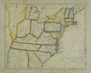
Map of the United States by Lucretia Deming
Object ID:
1950-01-90b
Category:
Made by Students
Medium:
watercolor and ink on paper
Creator:
Lucretia Deming (1804-1887)
Date:
1825
Held at:
Litchfield Historical Society
Associated Place:
Litchfield, CT
Size:
13 1/2" length x 11 1/4" width
Description:
Map of the United States in 1825. Depicts the eastern side of the country. Lines of lattitude and longitude drawn in ink. States are outlined in various shapes of watercolor paint. Important cities and waterways labeled in ink. Framed under glass
Associated People
- Lucretia Deming
Made by
Contact Us
Do you have more information for the Ledger?
If you have family papers, objects, or any other details you would like to share, or if you would like to obtain a copy of an image for publication, please contact us at curator@litchfieldhistoricalsociety.org.