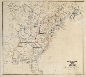
Map of the United States by Caroline Chester Knickerbocker
Object ID:
1909-21-0
Category:
Made by Students
Medium:
watercolor and ink on paper
Creator:
Caroline Chester Knickerbocker
Date:
1816
Held at:
Litchfield Historical Society
Associated Place:
Litchfield, CT
Size:
20 1/2" length x 25" width
Description:
Hand drawn ink map of eastern half of the United States with states and territories outlined in various water colors. Carouche with eagle in lower left corner. 26 degrees to 48 degrees latitude and a particularly American version of latitude with 0 degrees at Washington. Framed - black wood under glass.
Associated People
Contact Us
Do you have more information for the Ledger?
If you have family papers, objects, or any other details you would like to share, or if you would like to obtain a copy of an image for publication, please contact us at curator@litchfieldhistoricalsociety.org.